Indiana Geography for Kids: Printable US State Learning Pack
This post may contain affiliate links.
Next in our U.S. Geography series is Indiana! Known as The Hoosier State, Indiana is a Midwestern state with rich farmland, historic waterways, and a big role in American transportation and industry. From famous car races to limestone caves and rolling plains, Indiana offers plenty to explore through geography.
This printable Indiana geography pack helps kids learn about the state’s location, landmarks, and symbols with hands-on activities and map skills practice.
Studying all 50 states? Start here:
➡ United States Geography Lessons for Kids
Fun Facts About the State of Indiana
Start your Indiana state study with these interesting facts:
-
Indiana became the 19th state in the U.S. on December 11, 1816.
-
The state capital and largest city is Indianapolis.
-
Indiana is nicknamed “The Hoosier State,” a name used for its residents.
-
The state bird is the Northern Cardinal, and the state flower is the Peony.
-
Indiana is in the Great Lakes region. It borders Michigan, Ohio, Kentucky, and Illinois, and touches Lake Michigan in the north. The Ohio River creates the Southern border.
-
The Indianapolis 500, one of the most famous car races in the world, is held every year in Indianapolis.
-
Indiana is part of the Corn Belt, producing large amounts of corn and soybeans.
-
The Wabash River is one of the longest rivers in the state and inspired the state song.
-
Indiana limestone has been used to build famous structures like the Empire State Building and the Pentagon.
- Hoosier Hill is the highest point int he state and a notable landmark.
-
Abraham Lincoln spent part of his childhood in southern Indiana.
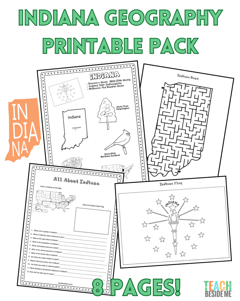
Indiana State Geography Printable Pack
This 8-page printable geography pack helps students explore Indiana’s geography through maps, research, and creative activities.
Included in this pack:
-
Indiana Fact Coloring Page (state bird, flower, flag, and animal)
-
Midwestern U.S. Regional Map
-
State Landmark Coloring Page – featuring the George Rogers Clark Memorial
-
Indiana Info Worksheet for student research
-
Blank U.S. Map to locate Indiana
-
Indiana State Map – label cities, rivers, and landmarks
-
Large Indiana State Flag Coloring Page
-
Indiana-Shaped Maze Activity
How to Use This Geography Pack
This pack works well for homeschool or classroom geography lessons:
-
Read through the fun facts to introduce Indiana.
-
Use the maps to locate Indiana and identify neighboring states.
-
Complete the info worksheet using an atlas or safe online research.
-
Reinforce learning with the coloring pages and maze.
-
Extend the lesson with a read-aloud or virtual field trip.
Recommended references:
Want to download this Indiana Geography pack? It is available in my shop for purchase.
![]()
Indiana Geography Learning Extensions
Read-Aloud Pairings:
-
Abe Lincoln Remembers by Ann Turner
-
Racing Around by Stuart J. Murphy (great Indy 500 tie-in)
Virtual Field Trips:
-
Explore the Indianapolis Motor Speedway Museum
-
Visit Indiana Dunes National Park along Lake Michigan
Hands-On Ideas:
-
Create a mini race car craft- Check out this post: LEGO Balloon Powered Car~ If I Built a Car
-
Make a limestone texture art project
More State Geography Lessons to Explore
Explore More U.S. States
Previous State: Illinois Geography Lesson
Next State: Iowa Geography Lesson