Learn the 50 States: United States Geography Lessons & Activities for Kids
This post may contain affiliate links.
Learn all about United States geography with this fun printable pack of activities! My daughter has been begging me to make her some fun USA geography activities. Together we picked out and planned many of the pages in this unit. She is thrilled with it and has been loving working through it. I love that my daughter is begging for geography!
This printable unit is designed as a starting point for learning about the United States. From here, we are diving deeper into each state with individual geography lessons and printable activity packs.
Over time, we will be exploring all 50 states, learning about their geography, landmarks, and symbols along the way.
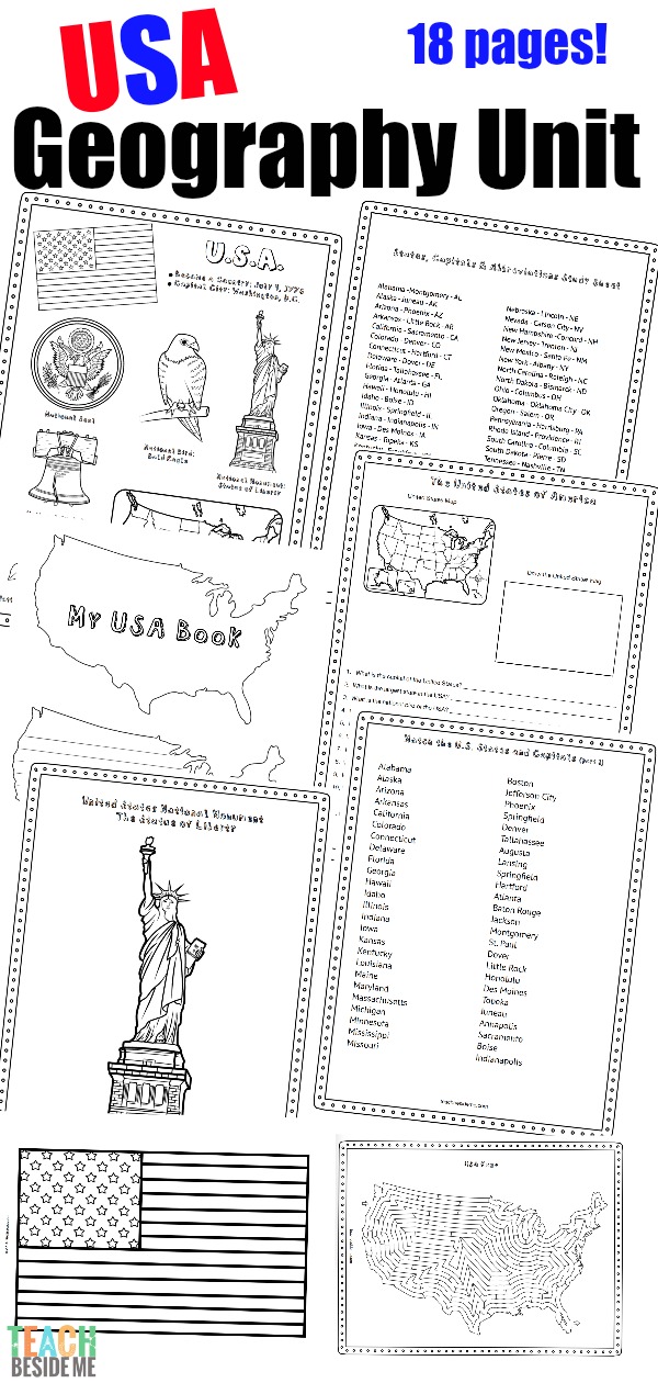
United States Geography Lesson Unit
This printable unit is 18 pages long and includes the following activity pages:
• Regions of the USA
• States & Capitals Matching
• States & Abbreviations Matching
• USA-shaped Booklet
• USA Dot-to-Dot
• USA Maze
• USA Tracing Page
• Label the States on the Map
• Questions about the USA
• World Map with USA labeled
• Statue of Liberty Coloring Page
• USA Facts Coloring Page
• Study Sheet with States & Capitals and Abbreviations

Using an Atlas for Geography Study
To do this lesson, kids will definitely need an atlas! You could find all of the information online (Wikipedia tends to be my kids’ go-to research source), but I personally think it’s important for kids to learn how to use an atlas.

We pulled out a couple that we had on hand. The Discovery Kids Atlas of the World had most of the information we needed, while the Usborne Geography Atlas was a little underwhelming for this particular project.
I am investing in a new United States atlas to use as we work through our state studies. I’ll share what we chose in an upcoming post!

Interested in Printing the USA Geography Unit?
You can find this United States Geography Activity Pack in my shop!
![]()
Exploring All 50 States
Along with this U.S. geography unit, I am also creating individual geography lessons for each of the 50 states. Each state includes fun facts, printable activities, and geography practice to help kids learn more about the United States.
I am working through all 50 states alphabetically in this geography series. Click a state below to explore printable activities, maps, and fun facts. New states are added regularly!
50 States Geography Lessons
A
C
D
F
G
Grab the discounted bunde of the first 10 states!
H
I
K
L
- Louisiana
M
- Maine
- Maryland
- Massachusetts
- Michigan
- Minnesota
- Mississippi
- Missouri
- Montana
N
- Nebraska
- Nevada
- New Hampshire
- New Jersey
- New Mexico
- New York
- North Carolina
- North Dakota
O
- Ohio
- Oklahoma
- Oregon
P
- Pennsylvania
R
- Rhode Island
S
- South Carolina
- South Dakota
T
- Tennessee
- Texas
U
- Utah
V
- Vermont
- Virginia
W
- Washington
- West Virginia
- Wisconsin
- Wyoming
I’ll add the rest of the links as they are created!
Printable State Geography Packs
Each state in this series includes a printable geography pack with activities like:
• State fact coloring pages
• Map labeling activities
• Landmark coloring pages
• Research worksheets
• State flag coloring pages
• State-shaped mazes
These printable packs make learning geography hands-on and engaging for kids.
Check out these geography posts, too:
Printable License Plate Game
Constitution Learning Resources
Geography Projects