Printable Delaware Geography Unit
This post may contain affiliate links.
I have been slowly working on a U.S. Geography series. Today, I have a state of Delaware geography learning pack to share with you. This Delaware geography printable pack has helpful resources to help teach your students about the state of Delaware. I hope you will add this to your geography or social studies lesson plans!
Studying all 50 states? Start here:
➡ United States Geography Lessons for Kids
Fun Facts About the State of Delaware:
But first, a few fun facts about the state to help you with your study of Delaware geography!
- The Dutch colonists were the first to settle in Delaware in 1631 near modern day Lewes. However historians believe Henry Hudson was the first to arrive and explore the area in 1609. It was previously inhabited by Native Americans including the Lenni Lenape and the Nanticoke tribes.
- Delaware was the first colony to ratify the United States Constitution on December 7, 1787, earning it the nickname “The First State.” But is also called “The Diamond State”, “The Blue Hen State” and “Small Wonder”.
- The state motto is Liberty and Independence.
- Delaware is the second smallest state in the U.S., measuring just 96 miles long and ranging from 9 to 35 miles wide.
- Delaware is one of a few states with no state sales tax, making it a popular shopping destination for nearby residents.
- The state is named after Thomas West, 3rd Baron Lord De La Warr, an English nobleman and Virginia’s first colonial governor.
- Despite Wilmington being the largest city, the state capital is Dover, known for its historic downtown and the Dover International Speedway.
- The state bird is the Blue Hen Chicken, which was used as a symbol by Delaware soldiers during the Revolutionary War. The state flower is the Peach Blossom, reflecting Delaware’s historic peach orchards.
- Rehoboth Beach is often called “The Nation’s Summer Capital” because it’s a favorite summer destination for people from Washington, D.C., and surrounding areas.
- The first scheduled steam railroad in the United States began operating in New Castle, Delaware, in 1831.
- Delaware has the lowest average elevation of any state in the U.S., with most of its land at or near sea level. Its highest point, near Ebright Azimuth, is only 448 feet above sea level!
- Delaware is located in the Atlantic Coastal Plain region, which means it has flat terrain with fertile soil. It’s great for farming and agriculture. They produce poultry, soybeans, corn, and more. Sussex County, in particular, is known as the “Chicken Capital of the World.”
- It borders Pennsylvania to the North, Maryland to the West and South, and New Jersey to the East divided by the Delaware River and the Delaware Bay. It also has coastline along the Atlantic Ocean to the Southeast.
- Howard Pyle, the author of the Merry Adventures of Robin Hood is from Delaware as well as Joe Biden, and Pierre S. du Pont, founder of the DuPont Company, which helped developed of materials like nylon, Teflon, and Kevlar.
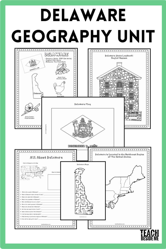
Delaware State Geography Printable Pack
This Delaware state geography pack is 8 pages and includes the following:
- Fact coloring sheet with the state bird, flower, flag, animal, a small map and more,
- Eastern states regional map
- State landmark coloring page
- Delaware info worksheet
- Blank map of the United States to draw in the state of Delaware
- Map of Delaware to label the location of the capital or other landmarks
- Large state flag coloring page
- Maze of the state of Delaware
This is great for elementary grades and even middle grades.
To use this printable worksheets pack you will need a pencil or pen, and colored pencils or crayons, a good United States atlas, or the internet if you’d rather go that route. I think learning to use an atlas is an important skill for kids, though.
We have two atlases that are great for kids that we are using as we work through this state series. Our favorite atlas is the The 50 States book by Gabrielle Balkan. It is a colorful illustrated book that my daughter loves looking through. It has almost all of the info we needed.
The United States Atlas from National Geographic Kids is a really useful one as well, in different ways. It has less details about individual states, but has more photos and real images. I felt like they each had great benefits and uses as we are learning about the geography of the United States.

This printable set is available for purchase in my shop.
![]()
Or, grab the bundle of the first 10 states!
See More Geography Lessons
Previous State: USA Connecticut State Geography Lesson
Next State: Florida Geography for Kids
See ALL the United States Geography Lessons
USA Landmarks Handwriting Practice
U.S. Presidents Trivia Game With Printable & Video