USA Connecticut State Geography Lesson
This post may contain affiliate links.
Next in our U.S. Geography series, we’re heading to the northeastern corner of the country to explore the state of Connecticut! This state is full of history, charming coastal towns, and scenic beauty. With this hands-on printable geography pack, students will learn about Connecticut’s location, landmarks, state symbols, and more.
Whether you’re working through a full U.S. state study or focusing on New England, this pack fits perfectly into your social studies or homeschool geography lessons.

Studying all 50 states? Start here:
➡ United States Geography Lessons for Kids
Facts About the State of Connecticut:
But first, a few fun facts about the state to help you with your study of Connecticut!
- The capital of Connecticut is Hartford, but Bridgeport is the largest city.
- Connecticut’s state tree is the Charter Oak
- The state bird of Connecticut is the American Robin.
- States that border Connecticut include New York (with Long Island Sound along the entire Southern border), Massachusetts on the North and Rhode Island on the East.
- The Sperm whale is the state animal of Connecticut.
- Connecticut’s state flower is the Mountain Laurel.
- The Dutch settlers were the first European colonists to arrive here, although the Native Americans were the first people here.
- It became a state in 1788 and was the 5th state.
- The Connecticut state nickname is the Constitution state.
- The Mystic Seaport Lighthouse is a famous landmark in Connecticut and was the center of shipbuilding since the 1600’s. It is now a museum and a replica of the one built in 1900.
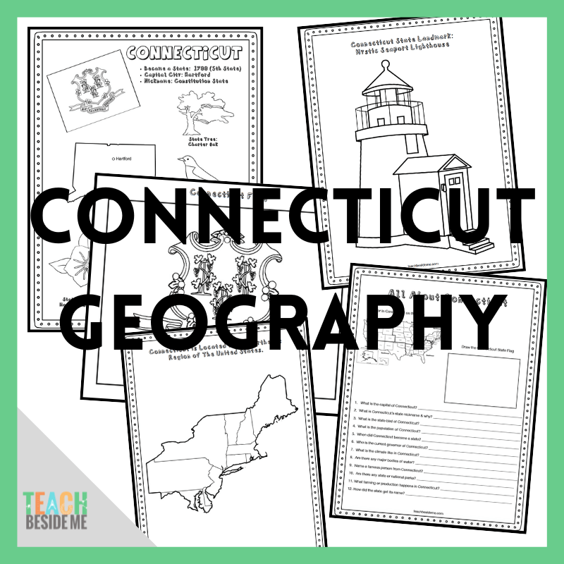
Connecticut State Geography Printable Pack
This printable geography pack includes 8 engaging pages that help kids explore the state of Connecticut through map work, research, coloring, and hands-on learning:
-
Connecticut Fact Coloring Page – features the state flag, bird, flower, and animal
-
Northeastern States Regional Map
-
State Landmark Coloring Page
-
Connecticut Info Worksheet – to record facts through research
-
Blank U.S. Map – students locate and label Connecticut
-
Connecticut State Map – label major cities, rivers, and regions
-
Large State Flag Coloring Page
-
Connecticut-Shaped Maze Activity
How to Use This Geography Pack
This set is print-and-go ready, making it easy to add into your week’s lessons. Here’s a suggested flow:
-
Read aloud the Connecticut fun facts as a warm-up.
-
Label the state maps and use the U.S. map to reinforce regional geography.
-
Use the info worksheet as a mini research assignment using a children’s atlas or online search.
-
Enjoy the maze and coloring pages to reinforce learning and add creativity.
-
Pair with a read-aloud or field trip idea (see below!).
You’ll only need pencils, crayons or colored pencils, and an atlas or internet access for research. We recommend:
Our favorite is the The 50 States book by Gabrielle Balkan. It is a colorful illustrated book that my daughter loves looking through. It has almost all of the info we needed.
The United States Atlas from National Geographic Kids is great as well, in different ways. It has less details about individual states, but has more photos and real images. I felt like they each had great benefits and uses as we are learning about the geography of the United States.
Connecticut Learning Extensions
Read-Aloud Pairing:
-
The Great Connecticut Caper – a serialized mystery book for kids featuring locations around the state
-
Where I Live by Eileen Spinelli – features a poetic story of a girl adjusting to a move to Connecticut
Virtual Field Trip Ideas:
-
Visit the Mystic Seaport or Mark Twain House online
-
Take a virtual campus tour of Yale University
Craft or State Symbols Extension:
-
Create a Connecticut state mobile featuring the robin, mountain laurel, and state flag
-
Paint or color the Connecticut River on a map and trace its route
Cross-Curricular Add-On:
-
Compare Connecticut’s population to other New England states
-
Graph temperature differences across the seasons
Connecticut Ocean Science Connection
Connecticut borders Long Island Sound, an important coastal ecosystem connected to the Atlantic Ocean. Oceans and large bodies of water play an important role in weather, transportation, and marine habitats.
Kids can learn about the layers of the ocean with our Ocean Zones Snack Cup, a fun edible activity that helps visualize the different zones of the ocean from the surface to the deep sea.
This printable set is available for purchase in my shop.
![]()
Or, grab the bundle of the first 10 states!
See More Geography Lessons
Previous State: Explore Colorado Geography
Next State: Printable Delaware Geography Unit
See ALL the United States Geography Lessons
USA Landmarks Handwriting Practice