Map the Olympics: A Fun Geography Activity for Kids
This post may contain affiliate links.
We love the Olympics in our house! Every two years when the Summer or Winter Games roll around, it’s the perfect opportunity to turn the excitement into meaningful learning.
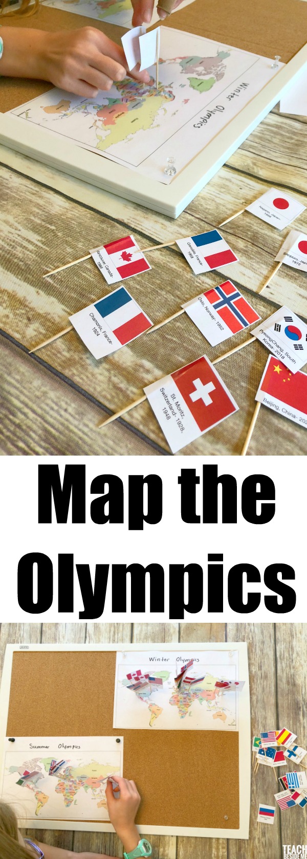
This hands-on Map the Olympics activity helps kids explore geography, history, and world cultures by mapping every Olympic host city from the very first Games to today. We divided ours into Summer Olympics and Winter Olympicsmaps so kids can see how the locations change over time.
It’s part geography lesson, part history lesson, and part world exploration — all rolled into one engaging project.
What Kids Learn from This Activity
Mapping the Olympics gives kids a big-picture understanding of the world and how international events connect countries across time.
This activity helps kids practice:
-
World geography and map skills
-
Recognizing country names and locations
-
Understanding timelines and historical events
-
Learning about global cultures and traditions
-
Comparing Summer vs. Winter Olympic host regions
Kids quickly notice patterns too — like how certain continents host more often, or how the Winter Olympics are usually held in colder climates.
What’s Included in the Map the Olympics Printable Set
This printable set includes everything you need to turn the Olympics into an interactive learning experience.
✔ World maps for:
-
Summer Olympics
-
Winter Olympics
✔ Printable flags for every Olympic host country
✔ Host city and date labels for each Games
✔ Color and black-and-white versions (great for student coloring)
How to Do the Map the Olympics Activity
1. Print the Materials
Print the maps and the Olympic host flags. You can use the color version or have students color their own flags.
2. Prepare the Flags
Cut out each flag, making sure to keep the city and year labels attached. Tape each flag to a toothpick or push pin.

3. Set Up Your Map
You can use:
-
The printable maps included in the set
-
A large classroom map
-
A cork board for easy pinning
We used two separate maps — one for Summer Olympics and one for Winter Olympics — to make it easier to see patterns.

4. Start Mapping
Students find each host city and place the corresponding flag on the map. This is where the real learning happens! Kids practice locating countries, reading maps, and noticing geography clues.

Ways to Extend the Learning
This activity easily turns into deeper lessons.
Try these extensions:
-
Have kids research one Olympic host country
-
Compare how host locations have changed over time
-
Discuss why certain countries host the Winter vs. Summer Games
-
Create a timeline of Olympic history
-
Learn about the origins of the Olympics in Ancient Greece
Why Kids Love This Activity
When I did this with my daughter, she was completely engaged. She loved discovering where the Games were held and was surprised by how many places she didn’t recognize at first. It turned into a great opportunity to explore new countries together.
Hands-on mapping makes geography feel like a treasure hunt instead of a worksheet.
Ready to Map the Olympics?
You can grab the full Map the Olympics Printable Set in my shop.
This set is perfect for:
-
Homeschool geography units
-
Classroom Olympic studies
-
World cultures lessons
-
History and timeline activities
$4.50Add to cart
![]()
![]()
![]()
Did you know you can get access to ALL of my printables in my Membership Site? They are also all listed on TPT if you prefer buying that way.
Want more Olympic Learning Activities?


One Comment