Kansas State Geography for Kids: Printable Learning Pack
This post may contain affiliate links.
Next in our U.S. Geography series is Kansas! Known as The Sunflower State, Kansas is famous for its wide-open prairies, farmland, and dramatic weather. Located in the heart of the Great Plains, Kansas has an important role in American agriculture and history. From pioneer trails to tornado science, there’s so much to explore in this fascinating Midwestern state.
This printable Kansas geography pack helps kids learn about the state through hands-on maps, fun facts, and engaging geography activities.
Fun Facts About the State of Kansas
Start your Kansas state study with these fun and interesting facts:
- Kansas became the 34th state in the U.S. on January 29, 1861.
- The state capital is Topeka, and the largest city is Wichita.
- Kansas is nicknamed “The Sunflower State” because wild sunflowers grow throughout the state.
- The state bird is the Western Meadowlark, and the state flower is the Sunflower.
- Kansas sits in the region often called “Tornado Alley” because tornadoes are common there.
- Much of Kansas is made up of flat plains and prairie grasslands.
- Kansas borders Nebraska, Missouri, Oklahoma, and Colorado.
- The famous book The Wonderful Wizard of Oz begins in Kansas.
- Kansas is one of the top wheat-producing states in the country and is sometimes called “America’s Breadbasket.”
- Historic trails such as the Oregon Trail and Santa Fe Trail crossed through Kansas.
- The Flint Hills region of eastern Kansas contains one of the largest remaining areas of tallgrass prairie in North America.
- Much of Kansas sits on layers of limestone, shale, and sandstone that were formed when the area was covered by an ancient inland sea millions of years ago.
- Kansas is home to many reptiles, including turtles, lizards, and several species of snakes that live in prairie and grassland habitats.
- Large underground deposits of salt are found beneath parts of Kansas. Some former salt mines are now used for underground storage.
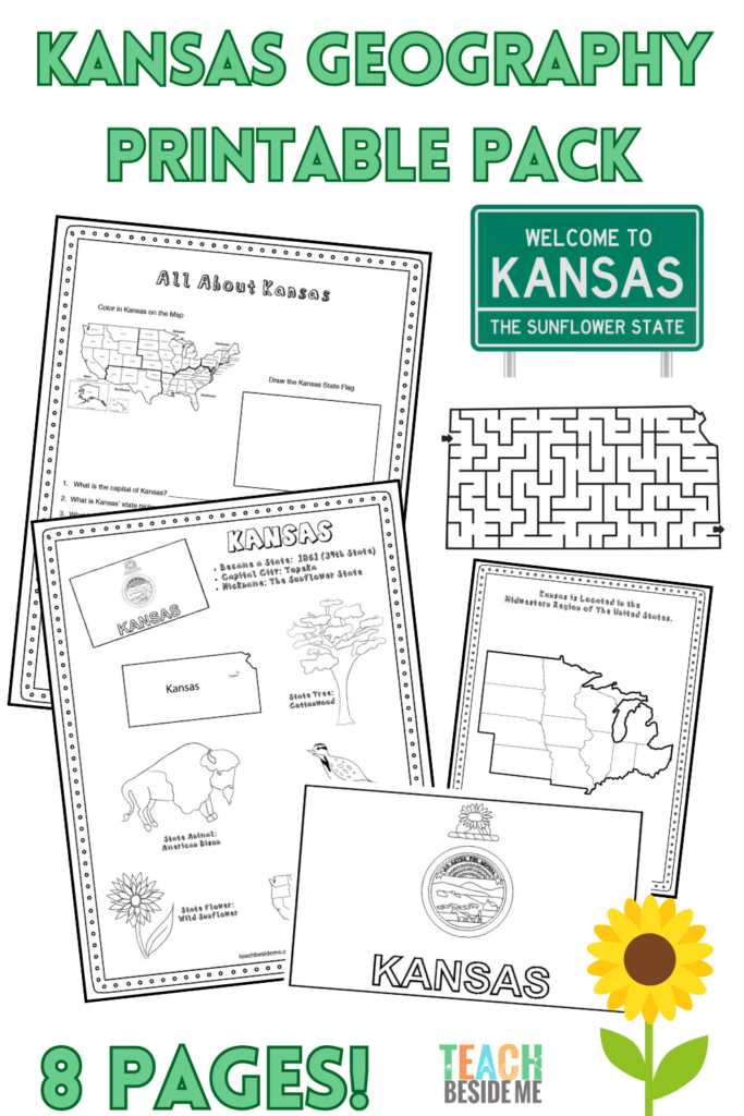
Kansas State Geography Printable Pack
This 8-page printable geography pack helps students explore Kansas through maps, research, and creative learning activities.
Included in this pack:
- Kansas Fact Coloring Page (state bird, flower, flag, and animal)
- Great Plains / Midwestern Regional Map
- State Landmark Coloring Page
- Kansas Info Worksheet for student research
- Blank U.S. Map to locate Kansas
- Kansas State Map – label cities, rivers, and neighboring states
- State Flag Coloring Page
- Kansas-Shaped Maze Activity
This Kansas geography pack is available in my shop for purchase.
![]()
How to Use This Geography Pack
This printable set is designed to work well for homeschool or classroom geography lessons.
- Begin by reading the fun facts together.
- Use the maps to locate Kansas and identify nearby states.
- Complete the research worksheet using an atlas or safe online resources.
- Reinforce learning with the coloring pages and maze activity.
- Extend the lesson with weather science or prairie-themed activities.
Recommended resources:
Kansas Weather Science Connection
Kansas is located in an area often called Tornado Alley, where warm and cool air masses frequently collide to create strong thunderstorms and tornadoes.
Kids can explore the science of spinning storms with this Tornado in a Bottle Experiment, a hands-on STEM activity that demonstrates how air movement can create a tornado-like vortex.
Kansas Geology STEM Connection
Kansas may look flat today, but millions of years ago much of the state was covered by a shallow inland sea. Evidence of this ancient environment can still be found in Kansas’s layers of limestone, shale, and sandstone, as well as fossils that have been discovered throughout the state. The famous Flint Hills region contains some of the largest remaining tallgrass prairie in North America and sits atop layers of chert-rich limestone.
Kids can explore how Earth’s surface changes over time with our Plate Tectonics Kinetic Sand Activity, which demonstrates how moving plates create mountains and other landforms. They can also become young geologists with our Identify Rocks With Kids activity and printable guide.
Kansas Geography Learning Extensions
Read-Aloud Pairings:
- The Wonderful Wizard of Oz by L. Frank Baum
- Moon Over Manifest by Clare Vanderpool
Virtual Field Trips:
- Visit the Kansas State Capitol online
- Explore prairie ecosystems and the Tallgrass Prairie National Preserve
Hands-On Activities:
- Create sunflower art or life cycle diagrams
- Compare prairie grasses and ecosystems
Cross-Curricular Connections:
- Graph wheat production by state
- Study tornado frequency across the United States
More State Geography Lessons to Explore
Previous State: Iowa Geography for Kids
Next State: Kentucky (Coming Soon!)