Arizona State Geography: Activities and Printable Pack
This post may contain affiliate links.
Arizona is an incredible state with diverse landscapes, rich history, and iconic landmarks. As part of our U.S. Geography series, I’m excited to share our Arizona Geography Printable Pack with you today!
My daughter and I are working our way through the United States one state at a time, and these printables have become a highlight of our homeschool lessons. She has loved researching and designing them with me, and I hope they’ll be just as engaging for your learners!

Studying all 50 states? Start here:
➡ United States Geography Lessons for Kids
Fun Facts About the State of Arizona:
Before you dive into the printable activities, here are some fun Arizona facts to inspire your study:
- Arizona became the 48th U.S. state on February 14, 1912.
- It is known as the “Grand Canyon State,” home to one of the Seven Natural Wonders of the World.
- The capital and largest city is Phoenix.
- Arizona shares borders with five U.S. states and Mexico.
- It has one of the most diverse landscapes in the country—deserts, mountains, forests, and canyons.
- The state flower is the Saguaro Cactus Blossom, and the state bird is the Cactus Wren.
- Arizona is one of only two states that does not observe Daylight Saving Time (except for the Navajo Nation).
- The famous Route 66 passes through Arizona, including the quirky town of Winslow, made famous by the Eagles’ song.
- Arizona is home to 22 federally recognized Native American tribes.

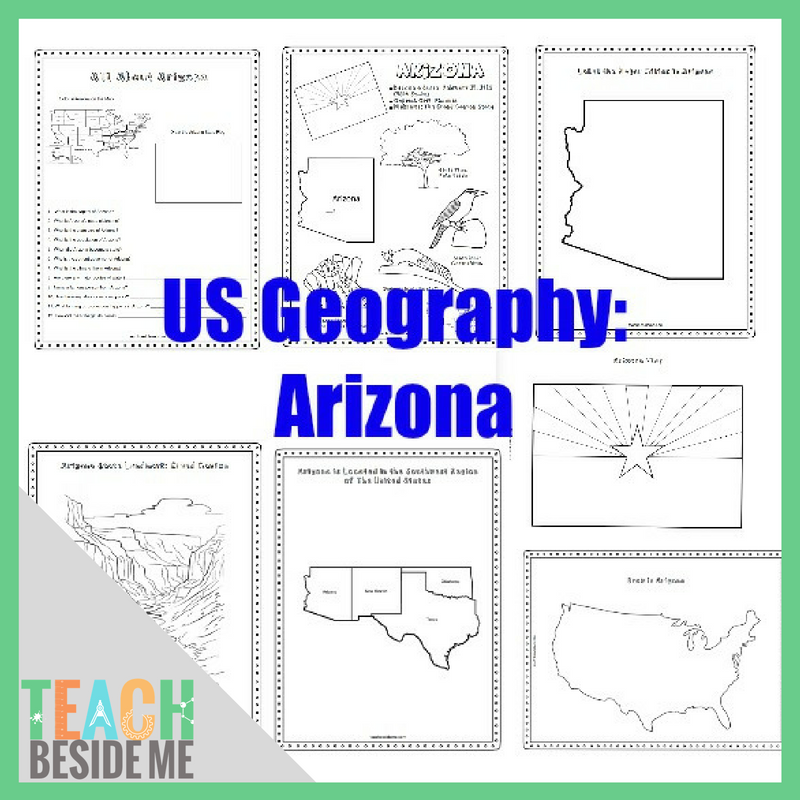
Arizona State Geography Printable Pack:
This printable geography unit includes 8 engaging pages perfect for elementary and middle-grade students:
- Fact coloring sheet featuring the Arizona state bird, flower, flag, animal, and more
- Southwestern states regional map
- Landmark coloring page featuring the Grand Canyon
- Arizona info worksheet with fun state trivia and research prompts
- Blank U.S. map to draw in Arizona
- Labeled Arizona map to mark cities, landforms, and capital
- Large state flag coloring page

These worksheets help build mapping skills, encourage research, and make learning about the 50 states fun and interactive.
Recommended Resources: To complete the activities, we recommend using a U.S. atlas or the internet. These are our go-to references:
- The 50 States by Gabrielle Balkan – a beautifully illustrated guide to each state
- National Geographic Kids United States Atlas – packed with real photos and kid-friendly maps

Additional Book Ideas About Arizona: If you’d like to expand your Arizona study, try these kid-friendly books:
- G is for Grand Canyon: An Arizona Alphabet by Barbara Gowan
- State Shapes: Arizona by Erin McHugh
- Celebrating Arizona: 50 States to Celebrate
Or check your local library for additional Arizona-themed titles.
Arizona Geology STEM Connection
Arizona is home to the Grand Canyon, one of the most spectacular geological formations in the world. Layers of rock exposed in the canyon help scientists understand Earth’s history.
Kids can become young geologists with our Identify Rocks With Kids activity and printable guide.
Want to Purchase the Arizona Geography Unit?
Get the Arizona Geography Printable Pack: You can purchase and download the Arizona printable pack from my shop today!
![]()
Or, grab the bundle of the first 10 states!
![]()
See More Geography Lessons
Previous State: Alaska Geography for Kids: Fun Facts and Printable Activities
Next State: Arkansas Geography for Kids: Printable State Activity Pack
- See ALL the United States Geography Lessons
- USA Landmarks Handwriting Practice
- U.S. Presidents Trivia Game With Printable & Video


Great looking free printable but how do I print it?