Free Printable World Map + 7 Continents Activity for Kids
This post may contain affiliate links.
You can also use the blank world map to make the giant felt continents map I’ve shared below. This has been one of my favorite hands-on geography projects because kids can remove the continents and put the world back together again like a giant puzzle.
Free Printable World Maps
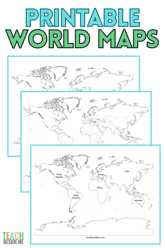
The free printable includes three world maps that can be used with different ages and geography lessons.
The printable includes:
- Blank world map with continent outlines
- Labeled world map with the 7 continents
- Blank world map with country borders
Use the maps for geography notebooks, continent identification, country studies, map labeling, or as reference maps.
DOWNLOAD THE FREE PRINTABLE WORLD MAPS
What Are the 7 Continents?
In the United States, children are commonly taught that there are seven continents:
- North America
- South America
- Europe
- Africa
- Asia
- Australia
- Antarctica
A simple way to begin teaching continents is to use the labeled world map as a reference and give kids the blank map to complete themselves.
Younger children can simply point to or name the continents. Older children can write the continent names, identify countries within them, compare their sizes and locations, and begin exploring the physical and cultural geography of different parts of the world.
What Are the 5 Oceans?
Along with the continents, kids can learn to identify the world’s five named oceans:
- Pacific Ocean
- Atlantic Ocean
- Indian Ocean
- Southern Ocean
- Arctic Ocean
Use the blank world map to practice locating and labeling the five oceans: Pacific, Atlantic, Indian, Southern, and Arctic.
This is also a great opportunity to help kids notice that our flat maps are representations of a round Earth. The Pacific Ocean, for example, appears on both sides of many world maps even though it is one connected body of water.
Why Do Some People Say There Are 6 Continents?
If you’ve learned that there are seven continents, you may be surprised to discover that not everyone in the world learns the continents the same way.
In the seven-continent model commonly taught in the United States, North America and South America are considered separate continents.
In some other educational traditions, North and South America are taught together as a single continent called America, creating a six-continent model. Another model combines Europe and Asia into Eurasia.
So if your child encounters a book, map, teacher, or person from another country who refers to six continents, it doesn’t necessarily mean one version is simply wrong. Different parts of the world use different conventions for defining and teaching continents.
For this printable, I’ve used the seven-continent model commonly taught in U.S. schools.
How to Make a Giant Felt Continents Map
Want to take your printable world map off the page?
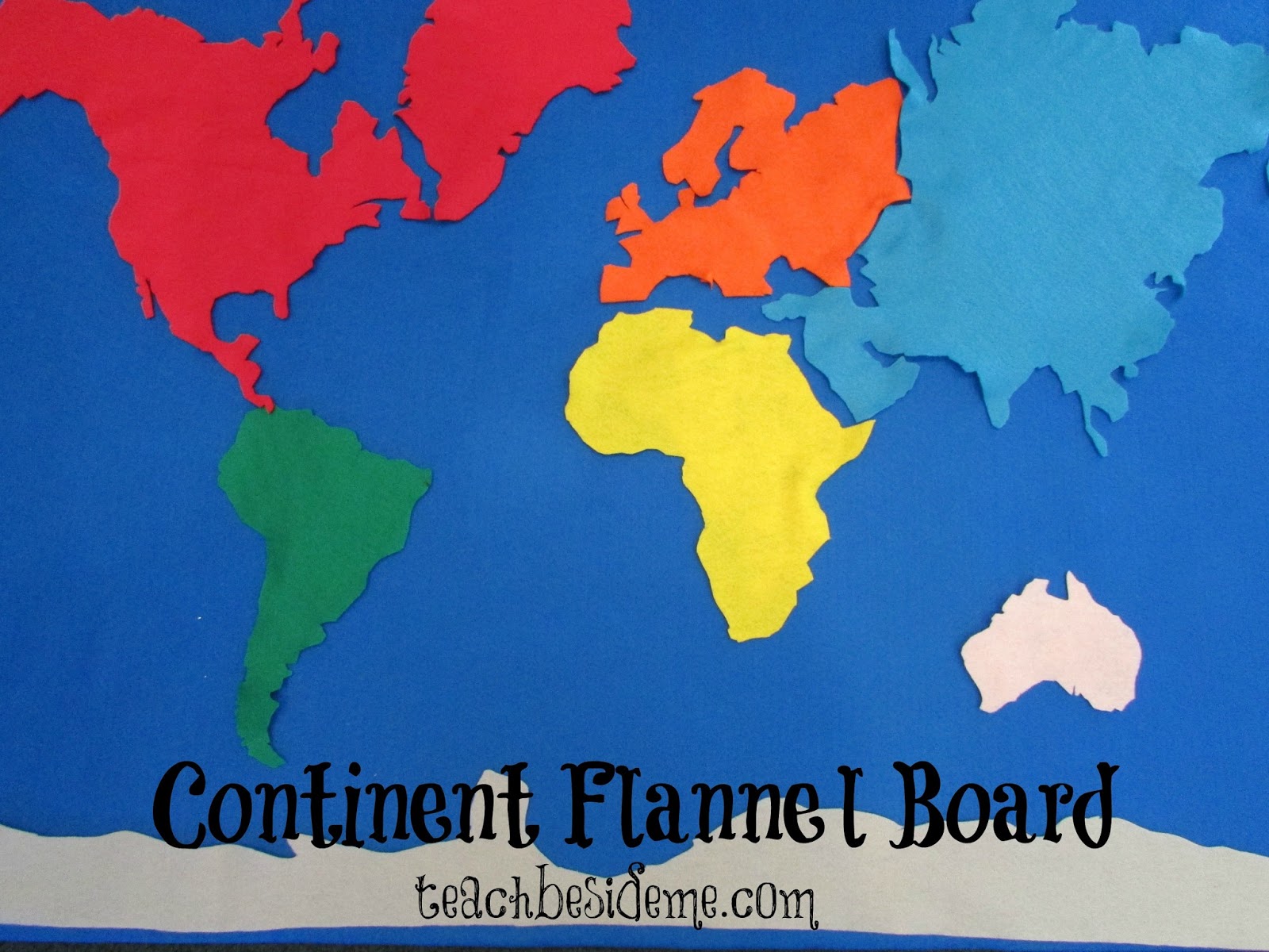
Years ago, I made this giant felt map with my kids as part of our Geography Projects from A to Z series. We were working through Geography from A to Z by Jack Knowlton, and C was for Continents.
The project took a little more cutting than I expected—continents have a LOT of edges!—but I loved the finished result.
The removable felt pieces turn a basic world map lesson into a large hands-on geography puzzle.
Supplies
You’ll need:
- Large tri-fold science project board
- Large piece of blue felt
- Several colors of felt for the continents
- My free blank printable world map
- Scissors
- Pins
- Tacky glue
- Foam brush, optional
- Paperclips or binder clips
You can use a different felt color for each continent to make them easier for younger children to distinguish.
How to Print the World Map Large
You don’t need a special large-format printer to make the giant map!
Download the blank world map PDF from the printable above and open it in Adobe Acrobat Reader.
Choose: Print → Poster → Tile Scale
Increase the Tile Scale until the map is the size you want. For a large project-board map, try approximately 300% and check the print preview before printing.
Adding a small amount of overlap between pages can make the pieces easier to align and tape together.
The map will print across multiple sheets of standard printer paper. Assemble the sheets to create one large world map.
You can also use this method to create different map sizes. A smaller enlargement works well for a tabletop map, while a larger version can become a classroom or homeschool geography display.

Make the Felt Continent Pieces
Once you’ve assembled your enlarged paper map, cut out each continent.
Pin each paper continent onto a different color of felt and carefully cut around it.
You may find that some of the tiny islands, narrow peninsulas, and intricate coastlines are difficult to reproduce in felt. It’s perfectly fine to simplify the shapes slightly for this project—the goal is to create recognizable continent pieces that children can handle and arrange.
Save your assembled paper map as a reference for placing the continents later.

Make the Felt World Map Board
Cut a large piece of blue felt to fit your tri-fold project board. The blue felt represents the oceans.
I used tacky glue to attach the felt to the board. You can spread the glue with a foam brush and use binder clips or paperclips around the edges to hold everything in place while it dries.
Once the background is completely dry, you’re ready to add the continents.

Build the World!
Now comes the fun part. Give your child the individual felt continents and have them arrange the pieces on the blue background. Keep the labeled printable world map nearby for reference at first.
As kids become more familiar with world geography, take the reference map away and see how much they can remember.
- Where does Africa belong?
- Which continent is directly south of North America?
- Where should Australia go?
- Which continents touch—or nearly touch—Asia?
The activity becomes part geography lesson and part giant puzzle.

Ways to Use Your Continents Map
Once you’ve made the felt map, you can use it for much more than memorizing seven continent names. Use it for many other mapping activities, too!
Try adding:
- Continent labels for kids to match with the correct pieces
- Ocean labels for the five oceans
- Pictures of animals to match with continents where they live
- Famous landmarks
- Major geographical features
- Flags or pictures from countries you’re studying
- People, foods, or cultural items from around the world
You can also remove all seven continents, mix them up, and challenge kids to reconstruct the world without looking at the reference map.
For younger children, start with just identifying and placing the continents. As their geography knowledge grows, continue adding new layers of information.
Learning Extensions
-
Label the Continents: Add Velcro labels or name tags your child can match and place.
-
Add Oceans: Cut and label the five oceans to add to the background.
-
Cultural Exploration: Add felt people, animals, or food from each continent.
-
Play Matching Games: Use cards or objects to match with the correct continent.
-
Memory Challenge: Remove all continents and see how many your child can place correctly!
More Ways to Use the Printable World Maps
You don’t have to make the felt project to use the free maps.
Try using the blank world map printable for:
- Labeling the seven continents
- Labeling the five oceans
- Coloring each continent a different color
- Locating countries you’re studying
- Mapping places you’ve visited
- Marking the settings of books you’re reading
- Tracking famous explorers or historical events
- Adding animals to their native regions
- Comparing climates and biomes around the world
- Geography notebooking
You could even laminate a copy or place it inside a dry-erase pocket so kids can use the same map again and again.
Learning Geography Through Hands-On Activities
Maps are an important part of learning geography, but I especially love giving kids opportunities to do something with the map.
Cut it apart. Put it back together. Label it. Add animals. Find a country from a book you’re reading. Trace a journey. Compare one part of the world with another.
Those experiences help turn the names and shapes on a map into places kids actually understand and remember.
This felt continents project was originally part of my Geography Projects from A to Z series. If you enjoy hands-on geography, you can continue with some of our other projects:
A is for Atoll & Archipelago
B is for Beach & Bay
D is for Delta
E is for Edible Earth’s Core




I am a huge fan of flannel, and I *love* how you used it for the continents! My head is just racing with other ideas for your continent pieces…like in a discussion of plate tectonics or Pangaea or even the water cycle! Thanks so much for linking up at Teach Me Tuesday at Preschool Powol Packets!
Wow! What a great idea! I really love this. I think I may make one using the Montessori Continent colors because we are going to study geography this year! Thanks for the idea!
Awesome, and you have some serious felt cutting skills!! 🙂
This is awesome!!!! I’m soooooooo doing this 🙂
This is so fantastic! And I actually have all the things I need to do it! Thanks so much for the tutorial.
Nice tutorial! This goes to my “to do” list!
I just loved this post! I featured you on the Hearts to Home Blog Hop this week :). Come on over to claim your featured badge!
http://www.onlypassionatecuriosity.com/hearts-for-home-blog-hop-1/
LOVE this! Way to go — we definitely need to start doing some geography around here. The kids are so interested when they’re young – need to capitalized on that!
Wonderful job! I think I may try this for countries as well
Great job!! Thank you for sharing at Sharing Saturday!
I LOVE your continent flannel board – what a great teaching tool!!
I featured this at TGIF this week here – http://www.123homeschool4me.com/2013/05/tgif-linky-party-78.html – Feel free to grab an I was featured button if you like.
Thanks for sharing all your creativity with all of us! I hope to see you linked up again later today!!
Have a great weekend,
Beth =)
Wonderful! Thanks for sharing!
Your continent felt board came out amazing!
Just gorgeous! Thanks for linking up at Discover & Explore this week — your post gets a double feature as Chelsey & I are both including it in our round-up of map activities 🙂