Explore Colorado Geography: Printable State Geography Pack for Kids
This post may contain affiliate links.
Bring Colorado to life with this hands-on printable geography unit! Whether you’re teaching in the classroom or at home, this pack is a fun and effective way to explore the Centennial State. Designed for upper elementary students, this resource is perfect for U.S. geography studies and includes a mix of maps, coloring pages, and fact-based learning.
We’re creating a full United States Geography series, and Colorado is just one stop on this learning adventure.

Studying all 50 states? Start here:
➡ United States Geography Lessons for Kids
Fun Facts About Colorado:
Before jumping into the activities, I always like to share some state facts! Here are some cool Colorado facts to share with your learners:
- Colorado became the 38th U.S. state in 1876, earning it the nickname “The Centennial State”.
- The state capital is Denver, which is also its largest city.
- Colorado has some of the highest elevations in the U.S., including Mount Elbert, the highest peak in the Rockies.
- The state flower is the Rocky Mountain Columbine.
- The Lark Bunting is the state bird, and the Bighorn Sheep is the state animal.
- Colorado is famous for its breathtaking natural landscapes, including Rocky Mountain National Park, Garden of the Gods, and Mesa Verde.
- It’s one of only three states where the borders form a right-angle intersection known as the Four Corners.
- The name “Colorado” comes from the Spanish word for “colored red,” referencing the red sandstone soil found in the region.
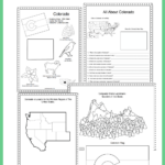
What’s Included in the Colorado Geography Printable Pack?
This 8-page set is designed to make state geography lessons interactive and fun:
- Colorado Fact Coloring Sheet – highlights key state symbols
- Colorado Map Worksheet – label cities, rivers, mountains, and more
- Blank U.S. Map – locate and draw in Colorado
- Western States Regional Map – see how Colorado fits into the region
- Colorado State Info Worksheet – complete facts using atlas or online research
- Garden of the Gods Landmark Coloring Page
- Colorado State Flag Coloring Page
These pages are great for grades 3–6 and help build mapping skills, attention to detail, and knowledge of U.S. geography.

To use this you will need a good United States atlas. We picked up two and are using them to work through this geography series.
Our favorite is the The 50 States book by Gabrielle Balkan. It is a stunning illustrated book and my daughter loves looking through it. It has almost all of the info we needed.
The United States Atlas from National Geographic Kids is great as well, in different ways. It has less details about individual states, but has more photos and real images. I felt like they each had great benefits and uses as we are learning about the geography of the United States.
We are excited to work through this entire series as a family and share it with you along the way. With 50 states, this will be a full year adventure for us! I hope you enjoy it.
This printable set is available for purchase in my shop.
![]()
Or, grab the bundle of the first 10 states!
Colorado Geology Connection
Colorado is famous for the Rocky Mountains, which were formed millions of years ago through powerful movements in the Earth’s crust. These movements are part of a process called plate tectonics, where huge sections of the Earth’s surface slowly shift and push against each other.
Kids can explore how plate movement shapes the land with this Plate Tectonics Kinetic Sand Activity, which demonstrates how mountains and landforms can form when plates collide and move.
➡ Try the Plate Tectonics Activity with Kinetic Sand to see how the Earth’s crust moves.
See My Other US Geography Lessons:
Explore More U.S. States
Previous State: Explore California: State Geography Printable Pack for Kids
Next State: USA Connecticut State Geography Lesson