Michigan State Geography for Kids: Printable Learning Pack
This post may contain affiliate links.
Welcome to another stop in our U.S. Geography series—Michigan! Known as The Great Lakes State, Michigan is surrounded by water and is famous for its beautiful lakes, forests, and automotive history. Made up of two peninsulas connected by the Mackinac Bridge, Michigan has one of the longest freshwater coastlines in the world.
This printable Michigan geography pack helps kids explore the state’s unique geography, landmarks, and symbols through hands-on maps, fun facts, and engaging learning activities.
Fun Facts About the State of Michigan
Start your Michigan state study with these interesting facts:
- Michigan became the 26th state in the United States on January 26, 1837.
- The state capital is Lansing, and the largest city is Detroit.
- Michigan is nicknamed “The Great Lakes State” because it borders four of the five Great Lakes.
- The state bird is the American Robin, and the state flower is the Apple Blossom.
- Michigan is made up of two land areas called the Upper Peninsula and Lower Peninsula.
- The Mackinac Bridge connects the two peninsulas and is one of the longest suspension bridges in the world.
- No point in Michigan is more than about 85 miles from a Great Lake.
- Michigan has more than 11,000 inland lakes and over 3,000 miles of freshwater shoreline.
- Detroit is known as the birthplace of the modern American automobile industry.
- The first assembly line used to mass-produce cars was developed by Henry Ford in Michigan.
- Michigan is one of the leading producers of cherries in the United States.
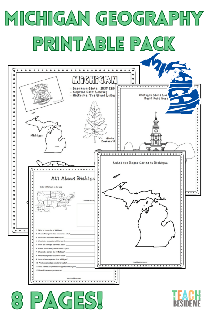
Michigan State Geography Printable Pack
This 8-page printable geography pack helps students learn about Michigan through maps, research, and creative activities.
Included in this pack:
- Michigan Fact Coloring Page (state bird, flower, flag, and animal)
- Great Lakes Regional Map
- State Landmark Coloring Page
- Michigan Info Worksheet for student research
- Blank U.S. Map to locate Michigan
- Michigan State Map – label cities, lakes, and neighboring states
- Large Michigan State Flag Coloring Page
- Michigan-Shaped Maze Activity
Get the printable pack now in my shop.

How to Use This Geography Pack
This printable set is designed for homeschool and classroom geography lessons.
- Begin by reading the fun facts together.
- Use the maps to locate Michigan and identify the Great Lakes.
- Complete the research worksheet using an atlas or online resources.
- Reinforce learning with the coloring pages and maze.
- Extend the lesson with one of the STEM activities below.
Recommended resources:
Michigan Great Lakes STEM Connection
Michigan is surrounded by four of the five Great Lakes, making it one of the most water-rich states in the country. The Great Lakes contain about 20% of the world’s surface freshwater and play an important role in transportation, weather, and ecosystems.
Check out my Salt Water Density Experiment or my Island- Water Sensory Play Activity.
Michigan Geography Learning Extensions
Read-Aloud Pairings:
- The Legend of Sleeping Bear by Kathy-Jo Wargin
- A is for Mitten: A Michigan Alphabet by Annie Appleford
- Paddle to the Sea by Holling C. Holling
Virtual Field Trips:
Hands-On Activities:
- Create a Great Lakes map project
- Build a bridge engineering challenge inspired by the Mackinac Bridge
Cross-Curricular Connections:
- Graph the sizes of the Great Lakes
- Compare freshwater and saltwater ecosystems
Find the Michigan State Geography Pack in my shop now!
More State Geography Lessons to Explore
See the full US Geography Series
Get this and all the State series in my Creative Teacher Club membership!